
Arkivo:Pyrenees topographic map-fr.svg

Grandezo di la previdado PNG de ica arkivo SVG: 800 x 475 pixels. Altra qualeso, en pixel-i: 320 x 190 pixels | 640 x 380 pixels | 1 024 x 608 pixels | 1 280 x 760 pixels | 2 560 x 1 520 pixels | 3 200 x 1 900 pixels.
Arkivo originala (arkivo SVG, nominale 3 200 x 1 900 "pixels", kun 6,3 MB)
![]()
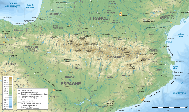
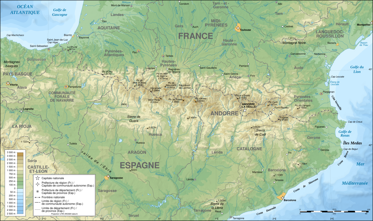
Detailed map of large dimension. For a better viewing, click on the link of the image above.
Carte détaillée de grande dimension. Pour une visualisation optimale, cliquer sur le lien de l'image ci-dessus.
Titulo
| Priskribo |
English: Topographic map in French of the Pyrenees mountains.
Note: The shaded relief is a raster image embedded in the SVG file. Français : Carte topographique des Pyrénées en francais.
Note : Le relief ombré est une image bitmap embarquée dans le fichier SVG. Português: Mapa topográfico (em Francês) dos Pirenéus.
Español: Mapa topográfico (en francés) de los Pirineos.
UTM projection; WGS84 datum; shaded relief (composite image of N-W, W and N lightning positions);
|
||
| SVG genesis | |||
| Dato | May 2007 (modified September 2008) | ||
| Fonto |
Own work;
|
||
| Kreinto | |||
| Yurizo (Riuzo di ica arkivo) |
|
||
| Georeferencing | If inappropriate please set warp_status = skip to hide. | ||
| Altra versioni |
[]
|


Assessment
|

This image was selected as picture of the day on Wikimedia Commons for 1 August 2007. It was captioned as follows: English: Topographic map in French of the Pyrenees mountains. Other languages:
Čeština: Francouzská mapa pohoří Pyreneje Dansk: Topografisk kort over Pyrenæerne på fransk. English: Topographic map in French of the Pyrenees mountains. Français : Carte topographique des Pyrénées en français. Magyar: A Pireneusok térképe Nederlands: Franse Topografische kaart van de Pyreneeën Português: Um mapa topográfico em francês, da região dos Pireneus. Română: Hartă topografică a munților Pirinei, Franța. Suomi: Topografinen kartta Ranskasta, Pyreneiden vuorilta. Svenska: Topografisk karta över Pyrenéerna på franska. Русский: Топографическая карта Пиренеев. Українська: Топографічна карта Піренеїв 中文: 法语注释的比利牛斯山地形图 中文(繁體): 庇里牛斯山的法語地形圖 עברית : מפה טופוגרפית בצרפתית של הרי הפירינאים |
Licencizo
Me, la proprietero dil autoroyuri pri ica verko, per to publikigos ol segun la sequanta yurizi:

|
On darfas kopiigar, distributar ed/od altrigar ica dokumento segun la kondicioni di GNU Free Documentation License, quale esas mencionita en la versiono 1.2 od en irga plu posa versiono, qua esas publikigita da Free Software Foundation; En la dokumento ne darfas esas ne-altrigita parti ed olu ne darfas esar kom texto di frontala o dopala pagino di libro o GNU Free Documentation License. |
| Ica arkivo liberigesas sub permiso Creative Commons Attribution-Share Alike 3.0 Unported. | ||
| ||
| Ica etiketo pri uzo-permiso ligesis ad ica artiklo dum l'aktualigo dil yurizo GFDL. |
Ĉi tiu dosiero estas disponebla laŭ la permesiloj Krea Komunaĵo Atribuite-Samkondiĉe 2.5 Ĝenerala, 2.0 Ĝenerala kaj 1.0 Ĝenerala.
- Vu povas:
- partigar – kopiar, distributar e transsendar la verko
- Mixar – adaptar l'arkivo
- Segun la sequanta kondicioni:
- Atribuo – Vu mustas referar l'artiklo o verko segun la formo definita dal autoro o dal proprietero dil autoroyuro, ed informar se modifikuri facesis. Vu mustas facar to per justa formo, ma ne insinuar ke l'autoro konfidis ol a vu, od aprobis vua uzo dil artiklo.
- partigar identa ('share alike') – Se vu modifikos, transformos od augmentos ica verko, vu mustos distributar la rezulto segun la sama, o simila licenco, quale l'originalo.
Selektez l'yurizo quon vu preferas.
Historio dil arkivo
Kliktez sur la dato/horo por vidar arkivo quale ol aparis ye ta tempo.
| Dato/Horo | Miniaturo | Dimensioni | Uzero | Komento | |
|---|---|---|---|---|---|
| aktuala | 00:05, 14 dec. 2012 | | 3 200 × 1 900 (6,3 MB) | Benh | uses Helvetica over Arial when available. |
| 15:49, 23 sep. 2008 |  | 3 200 × 1 900 (6,3 MB) | Sting | Using ETOPO1 data for bathymetry; new standard colors | |
| 00:25, 2 jul. 2007 |  | 3 200 × 1 900 (5,9 MB) | Sting | + projection info in key ; + major cities areas ; some corrections in the rivers | |
| 20:30, 25 jun. 2007 |  | 3 200 × 1 900 (5,88 MB) | Sting | + key for borders | |
| 21:18, 31 di mayo. 2007 |  | 3 200 × 1 900 (5,88 MB) | Sting | Some corrections | |
| 18:23, 30 di mayo. 2007 |  | 3 200 × 1 900 (5,88 MB) | Sting | {{Information |Description=Topographic map in French of the Pyrenees mountains |Source=Own work ;<br/>Topographic map : [http://www2.jpl.nasa.gov/srtm NASA Shuttle Radar Topography Mission] (SRTM3 v.2) (public domain) edited with [http:// |
Ligilo al imajo
Ca pagini ligas al imajo:
Uzado en altra Wiki
La sequanta Wiki anke uzas ica arkivo:
- Uzado en af.wikipedia.org
- Uzado en an.wikipedia.org
- Uzado en ar.wikipedia.org
- Uzado en azb.wikipedia.org
- Uzado en ba.wikipedia.org
- Uzado en bs.wikipedia.org
- Uzado en ca.wikipedia.org
- Uzado en cs.wikipedia.org
- Uzado en en.wikipedia.org
- Uzado en eo.wikipedia.org
- Uzado en es.wikipedia.org
- Uzado en et.wikipedia.org
- Uzado en eu.wikipedia.org
- Uzado en fa.wikipedia.org
- Uzado en fi.wikipedia.org
- Uzado en fr.wikipedia.org
- Ariège (département)
- Aude (département)
- Andorre
- Sentier de grande randonnée 10
- Haute-Garonne
- Hautes-Pyrénées
- Pyrénées-Orientales
- Pyrénées
- Liste des communes des Hautes-Pyrénées
- Discussion:Liste des communes des Hautes-Pyrénées
- Pau
- Béarn
- Bayonne
- Tarbes
- Adour
- Ariège (rivière)
- Vals (Ariège)
- Catalogne
- Aragon (communauté autonome)
- Huesca
- Bizanos
- Pays basque
- Discussion:Béarn
- Discussion:Pau
- Val d'Aran
- Prades (Pyrénées-Orientales)
- Haute-Navarre
- Lugdunum Convenarum
- Lourdes
Videz altra uzadi por ica artiklo.